Advancements in Aerial Imagery Technology for Ohio State Police
March 27, 2025 - 04:35
An Ohio State Police captain has revealed how the integration of airborne microwave downlink technology is significantly enhancing law enforcement capabilities. This cutting-edge technology allows officers to capture high-resolution aerial imagery in real-time, providing critical intelligence during various operations.
The system works by transmitting live video feeds from aircraft directly to ground units, enabling officers to assess situations from a bird's-eye view. This capability is particularly beneficial during pursuits, crowd control at events, and search and rescue missions. With the ability to monitor large areas quickly, law enforcement can make informed decisions and allocate resources more efficiently.
The captain emphasized that the technology not only improves operational effectiveness but also enhances public safety by allowing for better situational awareness. As law enforcement continues to embrace innovative tools, the integration of aerial imagery technology marks a significant step forward in modern policing strategies within the state of Ohio.
MORE NEWS
August 1, 2026 - 12:56
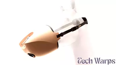
2s.design’s horse inhalation mask merges veterinary technology with natural form languageVeterinary equipment often looks like it was borrowed from a human hospital, but a new design called Equihero takes a different path. It is an anatomical inhalation mask made specifically for...
July 31, 2026 - 18:40
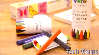
NC Made: Raleigh company helps families unplug and reconnect through creativityA Raleigh-based business is carving out a niche in the crowded toy and hobby market by focusing on something simple: getting families to put down their screens and make things together. The...

July 31, 2026 - 08:56
The Convergence Revolution — When AI Meets Every Emerging TechnologyArtificial intelligence rarely works in a vacuum. Its most transformative power comes from the point where it collides with other fast-moving fields. The current buzzword is convergence, and it is...

July 30, 2026 - 21:17
Spreading sunlight boosts algae productivity sixfoldResearchers at Michigan State University have found a way to dramatically increase how much algae can be grown outdoors. They developed a system that uses fiber-optic principles to spread sunlight...